Version History


-
5.6.1
A bugfix release focused on long-track performance, recording reliability, and map polish.
🚀 Performance
- Faster long tracks — large tracks now load and render faster, and powerful devices can handle a higher point threshold.
- More reliable storage — the database engine is more robust, and Geo Tracker now shows a small loading indicator while tracks are being read from disk.
🧭 Track handling
- Cleaner stop flow — Geo Tracker no longer asks for stop confirmation when nothing is being recorded.
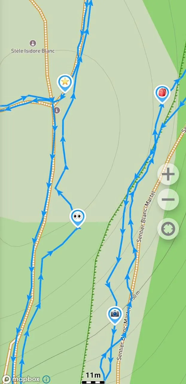
- Better split tracks — fixed missing comments and time inconsistencies in split tracks. You can now split a track at any marker on it.
- Directional arrow cleanup — fixed directional arrows lingering after a track is cleared on iOS.
- Track focusing fixes — focusing on tracks is now more reliable.
🗺️ Map
- Smoother navigation — map movement is smoother in navigation mode.
- Smarter marker visibility — marker display now turns on automatically when you add a new marker.
- Location marker fixes — fixed cases where the location marker would not appear.
📤 Sharing
- Map-only screenshots — you can now take screenshots of the map without statistics.
- Better screenshot names — screenshot files are now named using the track time.
- More reliable imports — fixed GPX, KML, and KMZ imports that could occasionally be dropped.
Thanks for being with us!
Want to try new features early?
Join our beta program:
- Android — tap “Join beta” on our Google Play page, or install the APK directly from our website.
- iOS — install via Apple’s TestFlight.
-
5.6.0
📍 Marker improvements
- Emoji waypoint icons — personalize the map with emoji markers: a tent for a campsite, an eye for a viewpoint, or a cup for a coffee stop. Emoji are preserved when exporting to GPX, KML, or KMZ.
- Easier waypoint organization — assign a waypoint to any trip, or create a new trip directly from the waypoint edit dialog.
- Safer editing — Geo Tracker now asks before discarding unsaved waypoint changes.
➡️ Directional arrows
- Travel direction on the map — tracks can now show arrows, so you can quickly see which way you were moving. You can turn them on or off in map settings.
- Note — directional arrows are currently available with Mapbox Maps only, because other map providers do not offer the required components.
📝 Trip comments
- Add more context to trips — add short notes like “France 2025”, “family hike”, or “bikepacking day 3”, see them in the trips list, and search by comment text when you need to find a specific trip later.
🌍 Language settings
- Switch language in the app — choose one of 11 supported languages directly in Geo Tracker, independent from your system language.
🚀 Performance
- Smoother large trips — smarter map loading keeps long tracks easier to browse.
- Lower memory use — displaying tracks now uses up to 50% less memory.
- Faster startup — launch time has been improved.
- Lighter exports — exporting large tracks uses less memory.
🛡️ System & stability
- Track point count — now shown in trip statistics.
- Guidance improvements — generated maneuvers and stop-markers are no longer marked as visited by default, and maneuver generation can now be undone.
- Low storage warning — Geo Tracker alerts you when your device is running low on storage.
- Calculation and compass fixes — improved vertical distance calculation and fixed compass calibration messages appearing at the wrong time.
- Cleaner track details — track dates are hidden when they match the trip name.
- Android 17 support — fully compatible with the latest Android release.
- Bug fixes — many stability improvements across Android and iOS.
-
5.5.1
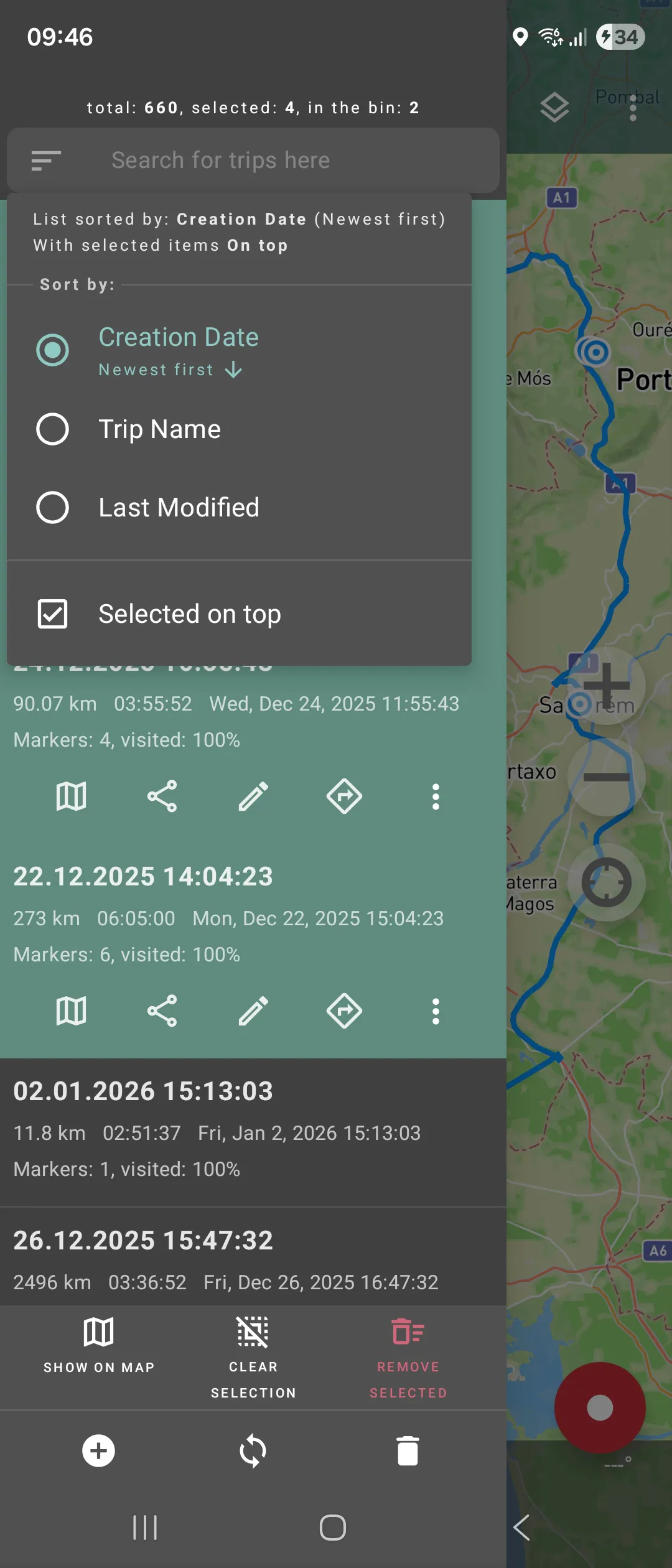
📝 New sorting options in the track list
You can now sort your tracks:
- by date,
- by name,
- by last modified, (in both directions – ascending or descending).
We also added ✅ a checkbox that allows you to always show selected tracks at the top of the list.
Super helpful if you manage lots of tracks!
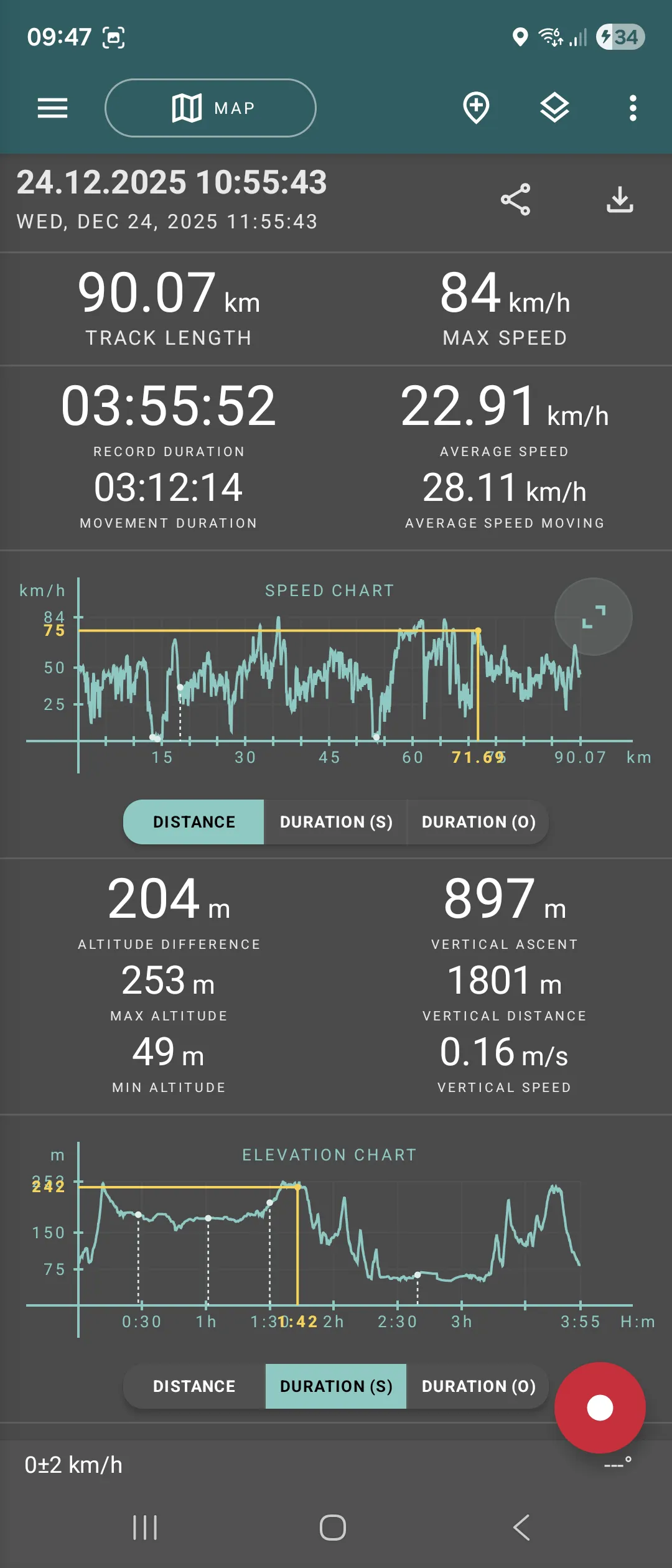
📈 New chart engine
We’ve completely reworked the chart rendering system:
- Chart intervals are now rounded - for example, instead of 2.51, you’ll see a neat tick at 3, and so on;
- You can now use the chart cursor even outside fullscreen - just slide your finger along the chart to view exact values;
- On iOS, fullscreen charts are now available too - tap to open and take a closer look;
- Charts are now more accurate and faster, especially on long or detailed tracks.
Thanks for being with us!
-
5.5.0
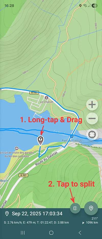
Track Splitting ✂️
- Split tracks into parts — ever forgot to stop recording and ended up with multiple activities in one track? Now you can drop a marker anywhere and split it into separate parts in seconds.
Performance 🚀
- Lower memory footprint — Geo Tracker now uses less memory for smoother operation.
- Faster rendering — maps and tracks load more quickly.
- Overall smoother experience — enjoy better responsiveness all around.
System & Stability 🛡️
- Bug fixes — we’ve resolved a bunch of annoying problems for a more reliable app.
Keep tracking and have fun out there! 🎒
Want to try new features early?
Join our beta program:
- Android — tap “Join beta” on our Google Play page, or install the APK directly from our website.
- iOS — install via Apple’s TestFlight.
-
5.4.2
Notifications and Status ✨
- iOS Live Activity — see current recording info on the Lock Screen and Dynamic Island.
- Redesigned recording notification on Android — cleaner, clearer, and easier to read at a glance.
Map View Options 🗺️
- Hide segment connectors — a new setting to toggle visibility of connecting lines between track segments.
System & Stability 🛡️
- Android 16 support — fully compatible with the latest Android release.
- GPX import improvements — better handling of complex or non-standard GPX files.
- Bug fixes — general reliability and performance enhancements.
Enjoy the update and happy exploring! 🚶♂️📍


-
5.4.1
Route Guidance Enhancements 🚀
- ETA display — see your estimated time of arrival right in Route Guidance mode.
Continuous Sync (Android) 🔄
- Live folder sync — with Auto-Sync enabled, your tracks are written to the external sync folder during recording.
- Near real-time tracking — pair this with a tool like FolderSync and you’ll have an almost online tracking experience.
- Configurable interval — adjust how often sync runs under Settings → Storage settings.
Import & Stability 🛠️
- GPX import fix — resolved an issue that blocked certain GPX files from loading.
- Miscellaneous improvements — assorted bug fixes and performance optimizations for a smoother experience.
Enjoy the refinements and safe travels!

-
5.4.0
Route Guidance 🚗
- New route guidance mode — use any saved route as a guided trip with on-screen prompts and maneuvers. Learn more in our route guidance guide.
File & Sync Improvements 🔄
- KML/KMZ support (iOS) — import and export trips in these formats on iPhone and iPad.
- Single-trip export (Android) — select “Sync this trip” to write one route to external storage.
- Enhanced sync & auto-start (Android) — more reliable folder scanning and automatic recording improvements.
3. Marker & Editing Enhancements 📍✏️
- Smarter markers — assign maneuver types, add notes, and access new waypoint settings.
- Live editing — tweak track descriptions (and other metadata) even while recording.
4. Map Features & UI 🗺️
- Night mode & traffic for Mapbox — switch to a dark theme and view live traffic where available.
5. Stability & Performance ⚙️
- Improved GPX export and numerous bug fixes for a smoother, more stable experience.
Enjoy the streamlined update—happy navigating!

-
5.3.7
Platform Support
- Geo Tracker for iPad — our stable iOS build now runs natively on tablets. Download via the App Store.
- Android 15 Ready — full compatibility with the latest Android release.
2. Immersive Map View
- True full-screen — top and bottom panels become translucent so your map fills the display.
3. iOS Enhancements
- Improved compass navigation — leverage your device’s built-in compass for even more accurate movement direction.
- GPX import fix — resolved an issue that could prevent GPX files from loading correctly.
Enjoy the broader device support and cleaner, more accurate mapping!

-
5.3.6 - Welcome iOS Users 🎉
Geo Tracker is now on iOS! Download from the App Store and read more here.
New Subscription Options
- Annual plans available — enjoy all premium features at a lower yearly rate.
- Switch between monthly and annual billing in Settings → Manage Subscription.
Smarter Recording
- Keep previous tracks selected — long-press the record button after choosing tracks in the list to retain your selection for the new session.
Garmin Watch Fix
- Resolved the issue causing constant vibration notifications on Garmin watches. No more interruptions!
Enjoy the new platform, savings, and smoother tracking experience!

-
5.3.4
- GPX route support — Geo Tracker now imports GPX files containing
<rte>(route) tags. - Enhanced KML/KMZ import — improved parsing of KML and KMZ files, with more reliable handling of waypoints and track segments.
- Hide “My location” button — toggle the on-screen location-pin button off in Display settings for an uncluttered map view.
- GPX route support — Geo Tracker now imports GPX files containing
-
5.3.3
Refreshed UI
- Slimmed top panel — takes up less screen space for a cleaner map view.
Trash Bin Enhancements
- Empty bin on demand — manually clear the trash, or let it auto-purge deleted routes after 30 days.
Stats Screen Update
- Recording date now appears under the route name in Statistics (and in shared screenshots).
Expanded Trip List Info
- See your total route count, plus how many are selected or in the trash, right in the trip list header.
5. Azimuth Display Fix
- Compass heading now shows as 0…360° (instead of -180…+180°) for unambiguous bearings.


-
5.3.2
Map Providers Overhaul
- Petal Maps added — enjoy Huawei’s Petal Maps in Geo Tracker: detailed vector data for many regions and full support on devices without Google Play services. (Note: Petal Maps does not include satellite imagery.)
- Yandex Maps removed — we’ve dropped Yandex support due to their new, prohibitive pricing policy.

-
5.3.0
Seamless Sync to Folder
- Sync to folder replaces separate import/export: drop GPX/KML/KMZ files into
/Documents/GeoTracker(or other folder) and tap Sync to load.
 - Auto-Sync (subscription required) — enable in Settings → Storage settings to import new files automatically on launch.
- Pro tip: Use FolderSync or similar to mirror this folder with cloud services (Google Drive, OneDrive, etc.).
Enhanced Trip Management
- Trash bin — recover accidentally deleted trips via the new bin, accessible from the trip list.
- Bulk delete — select multiple trips and remove them all in one tap.
Enjoy a smoother workflow and peace of mind knowing your trips are safe!

- Sync to folder replaces separate import/export: drop GPX/KML/KMZ files into
-
5.2.3
Automatic Stop Detection (Beta)
- Stop markers — Geo Tracker now flags points where you pause for some time.
- Enable in Settings → Record settings → Stop markers (Beta).
Bearing to Point
- Azimuth display — tap any marker or selected point to view the bearing (direction) and distance to it in real time.
Enjoy the new auto-stop feature and easier navigation cues!

-
5.2.1
Chart Enhancements
- Marker overlays on charts — see your waypoints directly in the graphs, marked with dots and dashed vertical lines.
Recording Profiles
- New “Airplane” profile — optimized settings for reliable GPS logging during flights.
Track Interaction
- Instant point info — drag along the route line on the map to view that point’s details in real time.
Search Improvements
- Expanded coordinate parsing — enter a wider variety of coordinate formats in the search dialog and jump straight to them.
Enjoy the sharper insights and new flight-friendly recording mode!

-
5.1.3
Automated Recording
- Tasker & MacroDroid support — trigger Geo Tracker to start/stop recording automatically. See our automation guide for setup.
New Sport Mode
- Ski statistics — Geo Tracker now computes downhill and uphill metrics for your ski sessions.
Android Compatibility
- Android 12 ready — full support and optimized behavior on the latest OS.
Navigation Improvements
- Landscape & startup fixes — Navigation Mode now initializes correctly in landscape and on app launch.
Background Recording Setup
Performance & Efficiency
- Faster stats & charts — smoother loading of statistics and full-screen graphs.
- Lower battery use — reduced background recording drain.
Enjoy the new automation features and improved performance!
-
5.1.2
Faster Trip Search
- Search bar in the track list—filter by name or description to quickly find and select any trip.
Flexible Units & Metrics
- Separate units for distance (km, mi, nm) and altitude (m, ft).
- Slope display now toggles between degrees and percent.
- Refined vertical distance calculation—more accurate ascent/descent based on your feedback.
Navigation & UI Tweaks
- Improved navigation mode—bottom panels no longer obscure your location arrow.
- Automatic compass off when speed exceeds 3 km/h (down from 5 km/h) for smoother tracking.
Smarter Markers
- Enhanced “add marker here”—markers dropped at your current position now auto-include location accuracy and its distance/time from trip start in the description.
Enjoy the faster search, more precise metrics, and cleaner navigation experience!

-
5.1.1
Performance
- Faster trip loading — optimized handling for routes with a large number of markers.
Statistics
- Improved algorithms — refined calculations for speed, elevation and other metrics. Tip: To apply the updates to existing routes, export them as GPX/KML and then re-import.
Recording Precision
- Higher-resolution distance triggers — now choose minimum recording distances of 50 cm, 10 cm, or 1 cm in your custom profile.
UI Simplification
- Always-on route display — the “show/hide route” toggle has been removed to avoid accidental hides. Selected routes now reliably appear on the map.
Enjoy the snappier performance and finer control!
-
5.1.0
Navigation Mode
- Navigation Mode — enable in Layers to have the map auto-rotate with your direction. Tip: Calibrate your compass by moving your phone in a “figure eight” for accurate readings.
- Compass toggle — turn off compass data in settings if you prefer GPS-only orientation.
Geolocation & Recording
- Location services check — the app warns you if GPS is off, prompts to enable it before starting a recording, and updates status if it’s turned off mid-recording.
- Battery optimization prompt — Samsung users will be reminded to disable battery savers before a background recording begins.
UI & Design
- Fresh look — updated icons, fonts, and colors; edit dialogs are now compact and no longer full-screen.
Recording Notifications
- Enhanced notification — your current speed, altitude, coordinate accuracy, and visible satellite count are shown in the ongoing recording alert.
Enjoy smoother navigation and a more reliable recording experience!
-
5.0.4
Expanded Cache
- Larger map cache — OSM/Mapbox now stores up to 256 MB (up from 50 MB).
2. Coordinate Tools
- Find by coordinates — enter decimal or DMS in the main menu to jump to any location. Also supports “open with” from other apps (e.g. Google Photos).
- Copy format choice — long-press the copy button to select decimal or degrees when copying coordinates.
4. Units & Display
- Nautical miles — new distance unit available under display settings.
- Hide status bar — fully hide the bottom panel via display settings for an uncluttered map view.
5. Screenshot Enhancements
- Stats-only screenshots — long-press the save/share button to capture just the charts and metrics, without the map.
6. Data Import & KML Support
- Closed paths from KML —
LinearRingpolygons now import as closed routes in the app.
7. Recording Profile Upgrades
- Custom profile options — new settings for recording rate and minimum distance thresholds.
8. Smarter Statistics
- Algorithm improvements — refined calculations for max speed, elevation, vertical distance, and slopes. Minor elevation noise is now ignored so you get more accurate vertical ascent/descent.
Thank you for all your feedback and track submissions—keep them coming! Enjoy the update.
-
5.0.3
Satellite Imagery for OSM/Mapbox
- New satellite layer — switch to satellite view when using OSM/Mapbox maps.
- High-res tiles powered by Mapbox for crisp aerial imagery.
Other Enhancements
- More precise speed display up to 30 km/h (30 mph) for finer-grained readings.
- Hide track endpoints — toggle off start/end markers on the map.
- Reduced memory usage — major optimizations when many tracks are open simultaneously.
Enjoy the update!

-
5.0.2
Reliable Background Recording
- Power-management guide — a new help article walks you through configuring your device’s battery and power-saving settings so Geo Tracker can record uninterrupted in the background.
Flexible Donations
- Upgraded payments SDK — our Google in-app billing library is now updated, so you can make the same donation multiple times if you like 😉.
GPS Week Rollover Fix
- Legacy device support — for older hardware that didn’t auto-apply the April 6, 2019 GPS week rollover, you can now enter a manual offset (
619315200) in Settings → Record Settings.
Enjoy the update, and thanks for helping us improve Geo Tracker!
-
5.0.0
New Map Source: OpenStreetMap
- Switch to OSM — now available alongside Google and Yandex maps, via Mapbox.
- Why OSM? Trails and minor paths often appear here first—perfect for mountain and off-road exploration.
- High-quality delivery — fast rendering, smart caching, powered by Mapbox (subscription required).
Recording & Compatibility
- Android 10+ support — background tracking has been optimized.
- Tip: Grant Allow all the time location access and disable battery optimizations (Samsung, Xiaomi, Huawei, OnePlus, Oppo, Realme, etc.). See setup instructions.
- A-GPS reset — clear and reload your device’s A-GPS data from Record settings if you encounter GPS glitches.
Map & UI Enhancements
- Redesigned map settings — quickly swap map sources (Yandex, Google, OSM) and layers (scheme, satellite, relief).
- Expanded status panel — now shows momentary azimuth, measurement precision, and more.
Elevation & Data Settings
- Sea-level baseline — switch from the default WGS84 ellipsoid to mean sea level for more accurate altitude readings.
- Manual baseline correction — offset your elevation baseline if needed (both options under Record settings).
Track Management
- Up to 100 open routes — load more tracks at once (warning: heavy RAM & battery usage).

-
4.0.0
Recording & Import
- Optimized background tracking — smoother, uninterrupted recordings. (Tip: whitelist Geo Tracker in your phone’s battery/recording settings.)
- Universal file opening — import GPX/KML/KMZ from any app (Chrome, Drive, WhatsApp, …).
Maps & Visualization
- Dark mode for Google Maps — perfect for low-light viewing.
- Persistent color mode — your preferred track colors (solid, speed gradient or elevation gradient) stick across sessions.
- New info panel — see current coordinates, satellite count, elevation, speed, recording and GPS status at a glance.
Navigation & Markers
- Redesigned markers — faster, more intuitive placement and editing.
- Coordinate copy — tap to copy any marker’s latitude/longitude.
- Live distance & bearing — real-time “how far and which direction” to your selected point.
Performance & Storage
- Rewritten storage engine — lightning-fast track loading and browsing. (First launch may take a moment to migrate your data.)
- Yandex Maps SDK update — upgraded for snappier performance and cleaner visuals.
- Note: Yandex no longer supports its Satellite layer—use Google Maps for satellite imagery.

-
3.3.0
Share Your Statistics
- Screenshot sharing — tap Share on the Statistics screen to send a full trip summary (map, charts, metrics) via Facebook, Twitter, email, or any app.
Full‐Screen Charts
- Immersive view — tap any chart to expand it full-screen, then pinch-zoom or pan to inspect details.
Duration-Based Charts
- New axis option — switch your charts between distance and duration directly from the Statistics screen for deeper insights.

-
3.2.1
Visualization
- Track color modes — now color your routes by speed or elevation gradient for instant visual insights.
File Formats
- KMZ support — import and export KMZ files just like GPX/KML.
Localization
- New languages — gracias a nuestros voluntarios! Geo Tracker now also in Spanish, Italian and French.
Recording Enhancements
- Auto-start recording — begin tracking automatically when you launch the app.
- Richer custom profiles — added new parameter values for your tailored recording settings.
Beta Program
- Join the beta — test upcoming features!
Enjoy the update and thanks for helping us make Geo Tracker better!

-
2.0.0
Marker Placement
- Control-panel button — tap the marker-pin icon to drop a marker at your current GPS position (with error feedback if fix is unavailable).
- Long-press & drag — touch and hold anywhere on the map, then drag the pin.
Route Planning
- Planning mode — start with a blank map, and add markers before you head out.
KML Waypoint Support
- KML import/export — load and save tracks and waypoints in standard KML format for easy sharing across apps.


-
1.0.0
Geo Tracker is published for the first time in Google Play.
-
Start of development